
Indio Street Directory Walkthrough
A street directory search works best as a five-part walk from a physical address to dated evidence. First normalize the address exactly as shown, including a hyphenated Indio number when one appears. Next use the county property search to find the APN and keep the situs address beside it. The APN is the bridge to the map, the assessor counter, the recorder’s party index, and permit records. It is not a resident list. The purpose of the chain is to separate parcel facts, ownership evidence, listed occupants, and public affiliations rather than blending them into one name result.
- Locate the parcel. Enter the street number and street name in the Riverside County property search. Capture the APN, situs, legal description, assessment year, and visible parcel facts.
- Read the map. Open Indio GIS and turn on address, parcel, building, road, district, and zoning layers. Confirm the parcel sits in the expected street segment and city or county jurisdiction.
- Check the owner channel. The online property tool withholds owner names. Take the address or APN to an assessor office for public inspection, then write down the roll date and the exact name returned.
- Follow the deed chain. Search that owner as a party in the recorder index. Confirm document type, recording date, document number, and legal description before linking a transfer to the parcel.
- Add time and context. Check city or county permits, a verified historical directory, or an approved record channel only when it answers the question. A listed subscriber or permit contact is not proof of every person at the address.
This sequence turns the Indio street directory from a vague name hunt into a repeatable record trail. Keep each query, result date, stable identifier, and access limit in a short ledger. When the goal shifts from one street to one person, the Indio resident lookup workflow uses a different verification path.
Turn an Indio Address into an APN
The county property search accepts an address or APN, making it the first practical tool for a street-by-street pass. In address mode, enter the street number with the street name. The county tip says to omit unnecessary suffix elements when a normal entry fails. City or ZIP can narrow a result, but postal geography can differ from a city line. APN search is an alternative when the parcel number is already known. The online card can show APN, situs, legal description, assessment year, land and improvement values, property characteristics, and tax-rate area.
The critical access split is simple: the online map can locate the parcel, while owner identity is public at an assessor office rather than displayed in the web result. The nearby Palm Desert counter is at 38-686 El Cerrito Road, Palm Desert, California 92211, with the research listing 760-863-7800 and public inspection access. The county’s policy keeps the owner field out of the online result, so a street directory that promises a web owner list would overstate what the official tool does.
Use the Riverside County property-search portal for the address-to-APN step.
| Field | Type | Required | Format or use |
|---|---|---|---|
| Street Number | Text | With street name | Numbers only for address mode |
| Street Name | Text | With street number | Omit surplus suffixes if needed |
| City or ZIP | Selector or text | No | Narrow with care because postal city may differ |
| APN | Text | Alternative | Use the county’s displayed parcel format |
| Search or Reset | Buttons | Action | Run or clear the query; no online owner-name mode |
Browse Indio Blocks with GIS Tools
The City of Indio GIS map adds spatial context after the APN is known. Its operational layers include address points, parcels, building footprints, development names, roads, city boundary and sphere, voting districts, tribal lands, flood and fault zones, zoning, and general-plan layers. The map supports a location-to-parcel-to-block workflow. It does not prove occupancy, and a drawn point or selected parcel should never be described as a person result.
Use the control that matches the task. Layer List turns useful data on or off. Select clicks or draws a feature. Buffer or Incident Analysis examines features within a stated distance. Bookmark returns to a saved extent. Measurement records distance, area, or coordinates. Draw can mark a research copy, and Print preserves the current extent as a dated view. A clear printed extent makes later comparisons easier when a boundary or parcel layer changes.
- Layer List
- Toggle parcels, addresses, districts, roads, zoning, boundaries, or other operational layers.
- Select
- Click or draw around mapped geometry to inspect nearby features and parcel context.
- Buffer
- Set a location and distance when a precise radius is more useful than a whole neighborhood label.
- Measurement
- Draw a line, polygon, or point to retain distance, area, or coordinate context.
- Save the current map extent and visible layers so a later record check has a date and scope.
For a second parcel channel, Riverside County Map My County offers address, APN, cross-street, legal-description, permit and case-number, road-book, district, township and range, query, measurement, print, and export controls. Its public help labels parcel-owner search as county use only. Use the public map for geometry and APNs, not a promised owner-name browse.
Note: GIS proximity shows mapped relationships, not household membership, a private identity, or current occupancy there.
Why Indio Owner Names Stay Offline
Riverside County’s online property privacy policy is the local insider tip that changes the street directory workflow. An address can return an APN and assessment facts on the web, but the owner name is intentionally absent from the online card. The county’s Assessor-County Clerk-Recorder ownership guidance describes the office route for ownership questions. Public inspection at an assessor office is the correct next step. This is not a broken search and not a reason to substitute an unverified compiled directory for the county roll.
At the counter, keep the APN, situs, legal description, and roll date distinct. An assessed owner as of January 1 is a dated land record. The mailing address may point somewhere else. Non-owner occupants, children, roommates, and other household members do not appear simply because an owner is listed. A tax bill or payment record adds information about the parcel obligation, not a complete list of people who use the address.
That online/offline split is useful evidence in its own right. It tells the reader where the official record stops. A sound Indio street directory describes the access channel and the missing field instead of implying that a web map can expose a private household.
Indio’s Address-Keyed Street Records
Several record sets can be lined up by address, but they do not all describe the same thing. The property search locates land. GIS shows geometry and jurisdiction. The recorder follows parties to recorded instruments. Permit files add a dated project trail. Voter data is restricted to approved purposes, and community groups publish only the contacts they choose to publish. This coverage map keeps the street directory useful without turning one record into a claim about every resident.
| Record set | Keeper | Street signal | Access |
|---|---|---|---|
| Property roll | Riverside Assessor | APN, situs, values, characteristics, assessed owner | Address/APN online; owner at office |
| Parcel GIS | Indio and Riverside County GIS | Parcels, addresses, buildings, districts, zoning, boundaries | Free map; no occupancy proof |
| Deeds and liens | County Recorder | Recorded parties, instruments, dates, legal descriptions | Web index from 1974; older Gateway route |
| Permit files | City Building and Safety or county TLMA | Project, applicant, contact, dates, APN, work class | Jurisdiction and CPRA rules apply |
| Voter file | California SOS or Riverside Elections | Approved registration data and status fields | Application and statutory purpose required |
The APN is the main join key for land records. The street name is a useful search clue, but it can change form, cross a boundary, or appear in more than one postal area. Keep the original query and the returned identifier so another researcher can reproduce the chain.
Follow the Indio Deed Chain by Owner
The recorder is indexed by parties and instruments, not by a reliable street browse. Once an assessed owner is identified at the counter, search that name as a grantee and narrow by deed type, date, and the parcel’s legal description. Then inspect the prior grantor and repeat. Deeds of trust, releases, and liens help place events in time, but they are supporting chronology, not automatic ownership transfers.
The advanced Riverside recorder search screen shows the fields used for a focused document query.
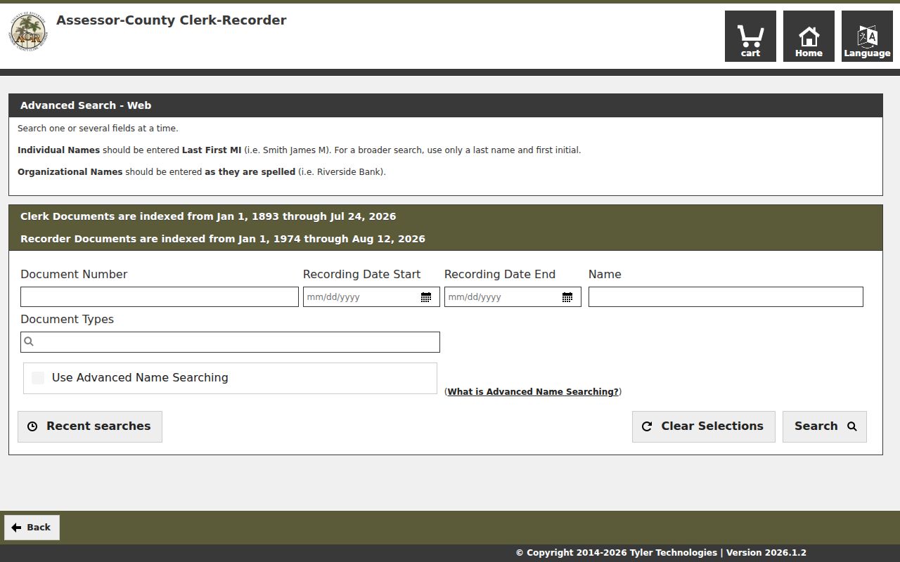
The image reflects a free index workflow with document number, recording-date range, name, document type, and advanced-name controls. It does not turn a web result into a full title opinion. The result locator can include party role, document number, recording date, type, and book, page, or map reference. The instrument image supplies the legal description and signatures.
- Keep the APN and legal description from the property record.
- Search the assessed owner as grantee, using surname order and spelling variants.
- Confirm the deed’s grantor, recording date, document number, and legal description.
- Search the grantor as an earlier grantee and repeat until the desired period is reached.
- For a pre-1974 instrument, use Gateway Riverside or the county’s older research route.
Recorder documents are indexed online from 1974, while earlier Riverside County work goes through Gateway Riverside. Online copies average 48 hours in the research notes; mail orders take about one to two weeks. The stated fee is $8 for the first page, $1 for each added page in the same document, and $2 for certification, with a 2.15% online card charge.
Note: A deed chain follows recorded instruments and parties; it does not reconstruct every household that used the address.
Indio Permits Mark Address Changes
Permit records can add a date to the physical history of a parcel. Inside Indio city limits, Building and Safety and the city EnerGov system are the proper route. Riverside County TLMA Permit Lookup applies chiefly to unincorporated land. Check the city-boundary layer before choosing the permit office. If an older file is not exposed through the city service, the Indio Public Records Center or City Clerk request route is the documented fallback.
The county permit form shows the fields that make an address search more precise: permit number, permit type, work class, street, city, APN, project name, description, subdivision, tract, lot, contact, square-foot ranges, applied, issued, finalized and expired date pairs, sort order, and page size. County data updates daily and may lag by 24 hours. TLMA is listed at 951-955-1800 for official or time-sensitive confirmation. City Building Safety is listed at 760-391-4110 and permitcenter@indio.org.
- Inside Indio
- Use the city Building and Safety or EnerGov route, then the City Clerk for historical material not exposed online.
- Unincorporated land
- Use Riverside County TLMA after checking the boundary layer and the parcel jurisdiction.
- Address evidence
- Read an applicant, contractor, owner, or contact field as a project connection with a date, not as a complete occupancy record.
A permit can show when work was applied for, issued, finalized, or expired. It cannot by itself prove who lived at the parcel when the work occurred.
Situs, Mailing, Plat, and Parcel Terms
Address records use short terms that sound alike but point to different evidence. Reading them correctly prevents a street directory from treating a tax notice, a mapped unit, and a deed description as interchangeable. The same parcel can keep its legal description while its postal label, number format, or mailing destination changes.
- Parcel
- A mapped unit identified by an APN. It is the county’s locator for assessment and map work, not a list of people.
- Situs address
- The physical location of the parcel or structure. It is the address to compare with GIS and permit records.
- Mailing address
- The destination for an assessment or tax notice. It may be away from the situs and does not prove occupancy.
- Plat
- A recorded map that lays out lots, blocks, streets, or other land divisions. An older plat may belong to a predecessor county.
- Criss-cross directory
- A reverse directory arranged by street or address. A verified local volume is needed before its conventions or coverage can be claimed.
For an Indio address, retain all five pieces when available. The APN joins map and roll data. The situs guides the street query. The mailing field explains where notices go. The plat and legal description help test an older deed. The reverse directory, if a real edition is found, adds a listed occupant clue rather than a title fact.
Note: The same street number can carry different evidence depending on whether the source is a map, roll, mailing field, plat, or directory.
Indio ZIP and Street Geography
USPS lists Indio city-name ZIPs 92201, 92202, and 92203. The first and third are street-delivery ZIPs. 92202 is associated with PO boxes tied to the 92201 service area and should not be mapped as a residential neighborhood. ZIP routes, Census ZCTAs, city limits, spheres of influence, and parcel jurisdiction are related but not identical. A ZIP search narrows a postal clue. It does not settle which office controls a parcel.
The physical street grid offers useful orientation. Numbered avenues run east-west, including 38th through 46th and beyond. Named north-south streets include Monroe, Jackson, Van Buren, Harrison, Oasis, and Calhoun. Highway 111 and I-10 divide practical search areas. The USPS city and state lookup should be used with the city GIS and parcel jurisdiction when an address sits near an edge.
Indio often prints five-digit addresses with a hyphen, such as 81-025 Avenue 40, while some databases normalize the same value as 81025. Try both forms when a street directory search returns no result. Verify any suspected change through a subdivision map, council record, permit, or the responsible custodian instead of inventing a renumbering history.
Reverse Directories for Indio Streets
A reverse directory can be the missing historical link from an address to a listed subscriber or occupant, but the local research gap matters. No official online finding aid confirms an exhaustive Polk city-directory or reverse-directory run for Indio. The Riverside County Library System, including Indio Library staff, and the Coachella Valley History Museum should be asked for a real edition before a year or publisher is stated. A regional title may contain Indio even when Indio is not in the title.
Verified Library of Congress telephone reels include Riverside County white and yellow pages from June 1921 through February 1925, August 1925 through August 1933, and December 1934 through September 1941. Coachella regional volumes cover November 1946 through December 1957 and December 1958 through January 1962. Search the printed locality or exchange index inside each reel. White pages can show subscriber, printed address, and telephone. Yellow pages add a business category. The records do not prove title, a spouse, or a complete household.
When a volume is located, record its printed date, locality heading, page, exact address typography, spelling, and telephone exchange. Compare the reverse entry with the alphabetical section and with a deed, census, obituary, or permit. A name that disappears can reflect a move, a changed surname, initials, unlisted service, a regional-volume gap, or a publication delay. The Indio city directory collections page carries the historical shelf method in more depth.
Note: A reverse-directory line is a dated published clue, not a current resident certification for the address.
Indio Street Directory Privacy Limits
No public street search supplies a complete list of people at an address. Household members who are not assessed owners, children, roommates, utility customers, and people without a listed telephone can be absent. DMV address data is restricted under the federal Driver’s Privacy Protection Act, 18 U.S.C. §§2721-2725, and California confidentiality rules. Voter data is not an open street browse. Community, neighborhood, watch, and association rosters are private unless the organization chooses to publish an officer or contact list.
California’s Safe at Home program can interrupt an address trail for eligible people. Protected court, juvenile, adoption, victim, vital, and confidential-voter records can also create a deliberate gap. A missing name is therefore not evidence of a vacant parcel, a missing household, or a failed identity. It may only show that the source is outside public access or outside its own coverage.
Lawful use. Use Indio street and address records for focused, lawful personal research, civic review, family history, or an official copy request. Never use a parcel, name, map, or voter record to stalk, harass, intimidate, or harm another person.
The most reliable street directory result states what the record confirms, what it does not confirm, and which custodian can answer the next question. A parcel can establish land context. A deed can establish a recorded transfer. A directory can establish a printed listing. None alone establishes every current resident.